Possible Routes
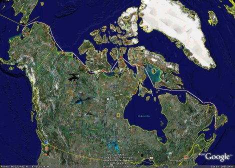
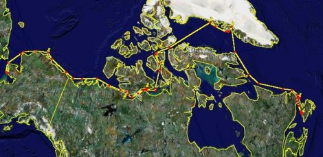
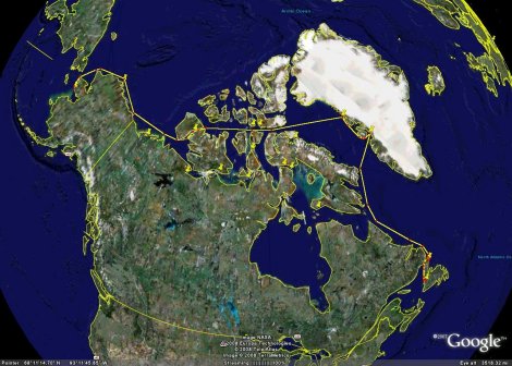
There are three possible routes that Geraldine may take through the Northwest Passage.
Alternative Route # 1
This is the shortest route, but also the least likely to be navigable due to ice conditions. This route takes us through the 105 mile long Fury & Hecla Strait which has, historically, always been ice covered. If recent warming trends continue, and with a little bit of luck, we’re hoping that there might be a chance for us to sneak through this more desirable route. The Strait has opened up in recent years. The Canadian Coast Guard icebreaker AMUNDSEN transited the Strait in October 2006 — very late in the season — yet to everyone’s surprise, they found open water. We will probably be coming too early in the season…but strange things have been happening in the Arctic lately.
The problem is that we’re going to have to make a call prior to turning west out of the Labrador Sea into Hudson Strait. If we do attempt this route, then we discover that we can’t negotiate Fury & Hecla, this will cost us well over 1000 miles of extra travel to go back out to the Labrador Sea and take one of the other alternative routes via Greenland. Note that after Fury & Hecla, this route also takes us through the very narrow Bellot Strait between Somerset Island and the mainland (the northernmost mainland point in North America). Bellot is another very treacherous strait with a very strong current, however if we find that strait to be too dangerous to attempt, it would only cost us a few hundred miles to run up and around Somerset Island and come down into Peel Sound.
Alternative Route # 2
This is more the “traditional” route of the Northwest Passage. It is also (with the exception of Gjoa Haven) the route taken by the Norwegian Roald Amundsen in the first successful transit of the Passage in 1903-1906. If time allows, we will add Gjoa Haven to our route as well. This is the longest route that we are considering, but also one that has a certain “comfort level” (if that’s possible) since we know that others have been successful taking this route. It would also bring us to places where we have already established local contacts such as Resolute and Cambridge Bay. We would leave Cambridge Bay and head westward through Coronation Gulf, Amundsen Gulf and into the Beaufort Sea, refueling in Tuktoyaktuk, Northwest Territories, then continuing westward across the southern Arctic Ocean to Prudhoe Bay and Barrow, Alaska.
At the beginning, this route would take us eastward across Davis Strait to Disko Bay and Ilulissat, Greenland where fuel will be available. There, we would also get to view one of the largest (and fastest moving) glaciers on earth, the Jakobshavn Glacier. Although it seems out of the way, this crossing will enable us to avoid the dangerous “iceberg alley” along the east coast of Baffin Island. From Disko Bay, we will follow the west coast of Greenland northward, refuel again in Upernavik, then head back west across Baffin Bay and enter the Passage via Lancaster Sound. This route will also take us by Beechey Island where British explorer Sir John Franklin’s ill-fated 1843 expedition spent their first winter…and where the first three members of his crew died and were buried. Their headstones can still be seen there today. The rest of the 129 crew members died over the two subsequent winters after their two ships, EREBUS and TERROR, were eventually crushed by the ice and sank.
Alternative Route # 3
This route is another one that we are considering because of the recent warming trend in the Arctic and the somewhat surprising receding of the ice cover in both M’Clure and Prince of Wales Straits in the Northwest Territories. The first part of this route is the same as Route # 2, but instead of going south from Resolute into Peel Sound, this route would take us further westward from Resolute through Barrow Strait, Viscount Melville Sound and toward M’Clure Strait where we would turn southwest into the narrow Prince of Wales Strait between Victoria Island and Banks Island. We would exit the southwest end of Prince of Wales Strait into the Amundsen Gulf at which point we are basically through the Northwest Passage. We would have to make a stop in Tuktoyaktuk, Northwest Territories to refuel, then head west across the Arctic Ocean toward Prudhoe Bay and Barrow, Alaska.
This is somewhat of a slam dunk route through the Passage, bypassing many of the local hamlets that we might like to see but, nevertheless, getting the job done. The call on Route # 2 vs. Route # 3 will be made before we leave Resolute, based on ice intelligence that we receive from the Canadian Coast Guard, the Canadian Ice Service and the daily satellite images that we receive. Even as early as mid-June 2008, there were indications that the ice in Prince of Wales Strait was beginning to soften. European Space Agency satellite photos from August 2007 show both M’Clure and Prince of Wales Straits wide open with only a few traces of brash ice here and there.
Observations from Last Year
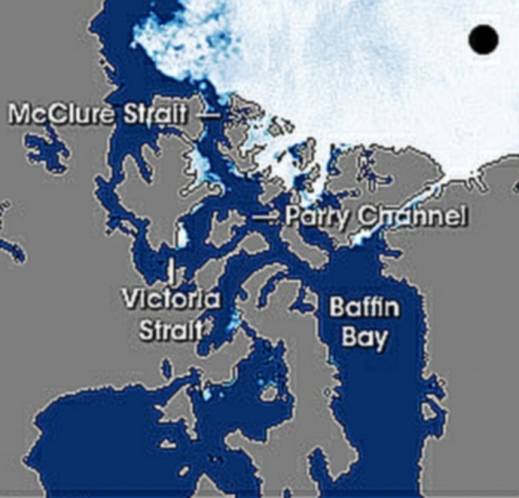
This is a satellite image of the ice cover in the Northwest Passage taken on August 22, 2007. For reference, the black dot in the upper right hand corner is the North Pole. This is as open as the Passage has ever been on this date.
Bearing in mind that this 2007 image was taken 3-4 weeks after we will be transiting the Passage in 2008, nonetheless, we should make some observations from this image relative to our three proposed alternative routes:
- Alternative Route #1: Foxe Basin is completely ice free as is Fury & Hecla Strait, however, Fury & Hecla may not be the real issue here — it will more likely be the east coast of the Gulf of Boothia which, as we have already been warned, may be clogged with drift ice. This image shows that even on August 22nd, the west end of Fury & Hecla was still clogged at the Gulf of Boothia. Favorable winds would probably alleviate this problem (temporarily).
- Alternative Route #2: This “traditional” Northwest Passage route via Victoria Strait was completely ice free on August 22nd, as was reported by two other expeditions that got through last year (the American CLOUD NINE and the British LUCK DRAGON). This is very encouraging!
- Alternative Route #3: Note that on August 22nd M’Clure Strait was open but the south side of Viscount Melville Sound still had a lot of fast ice with a little on the north side as well. Note too that Prince of Wales Strait appears to be blocked at the northeast end. We’ll have to watch these two areas closely before we decide to deviate from Route #2 for Route #3.


